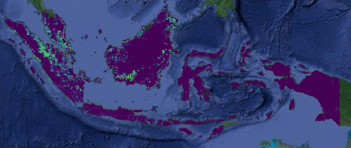
 Oil palm density map from 2017. We estimate a total of 1.7 billion oil palms Indonesia and Malaysia.
Abstract
Oil palm is one of the major oil crops in the world. Accurate mapping is fundamental for understanding its past and future impact on the environment. Beyond traditional land cover classification, we propose to use tree densities per pixel for large scale oil palm analysis. This allows for a much finer-grained analysis, for instance regarding different planting patterns. To that end, we propose a new, active deep learning method to estimate oil palm density at scale of from Sentinel-2 satellite images, and apply it to generate complete maps for Malaysia and Indonesia. What makes the regression of oil palm density challenging is the need for representative reference data that covers all relevant geographical conditions across a large territory. Specifically for density estimation, generating reference data involves counting individual trees. To keep the associated labelling effort low we propose an active learning (AL) approach that automatically chooses the most relevant samples to be labelled. Our method relies on estimates of the epistemic model uncertainty and of the diversity among samples, making it possible to retrieve an entire batch of relevant samples in a single iteration. Moreover, our algorithm has linear computational complexity and is easily parallelisable to cover large areas. We use our method to compute the first oil palm density map with $10,$m Ground Sampling Distance (GSD) , for all of Indonesia and Malaysia and for two different years, 2017 and 2019. The maps have a mean absolute error of +-7.3 trees/ha, estimated from an independent validation set. We also analyse density variations between different states within a country and compare them to official estimates. According to our estimates there are, in total, > 1.2 billion oil palms in Indonesia covering > 15 million $ha$, and >0.5 billion oil palms in Malaysia covering >6 million ha.
Andres C Rodriguez
Bridge Fellow (PostDoc) at Kapok.ai/ETH Zurich
My interest is in developing algorithms that leverage Remote Sensing data for environmental and sustainability purposes.